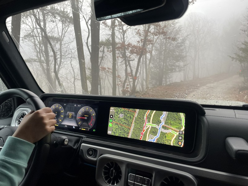
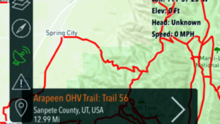
ATV Riding—There’s an App for That

February 1st, 2013 by Jason Giacchino

ATV-Escape
When it comes to harnessing the power of the digital age in off-roading, the first that may come to mind is electronic fuel injection, tuneable fuel maps or digital ignitions but the fact of the matter is the popularity of the cell phone literally puts the power of the world’s digital network right at our fingertips.

To that end we’ve been stoked about a 100% free app called ATVESCAPE for iPhone & Android devices.


Currently on Version 3, the app puts the entire ATV/UTV industry in the palm of your hand. ATV Escape determines where you are on the planet then compiles everything in the area that could possibly be of interest: 650+ trails and tracks, 15,000+ ATV UTV/Dealers, 70,000+ lodgings, rentals, events, special offers, and more.


If that weren’t enough it gathers up and makes accessible the latest ATV news, reviews, articles, pics and vids from around the web to keep you “in the loop” even when you’re busy tearing up your favorite loop.


More info and direct download links can be found here, or you can search for “ATVESCAPE” in the App Store or Google Play to download the app for free”.

Check out this highlighting the app’s ease of use and feature set!

What is it about ATV/ UTV riding that makes it such a perfect communal activity? Unlike hiking, model building and bird watching, there is something about the roar of an ATV’s engine, the scent of the fresh wooded air, and the possibility of endless exploration that absolutely begs for the group dynamic. Perhaps it’s the joys of sharing stories after with those were actually there, the camaraderie, competition, or maybe we just being surrounded by others equally obsessed to make ourselves feel normal. Whatever the reason, ATV festivals make perfect sense to us and here are a few we think may make sense to you as well.

Tackle Dunes by the Sea >>


Southeastern ATV Trails

January 1st, 2006 by admin

 
undefined
 

Search for Recreational Opportunities on Federal Lands

State Recreational Trails Programs


Alabama
Louisiana
Arkansas
Mississippi
Florida
South Carolina
Georgia


Alabama

State Recreational Trail Funding Program

Alabama National Forests
Alabama State Page
Kentuck ORV Trail

Talladega National Forest – Kentuck ATV Trail
Contact for trail maps & info : Talladega Ranger District
1001 North St.
Talladega, Al. 35160
(205) 362-2909

Bankhead National Forest   (Reopened)
Directions to ORV trail:
      From Alabama Hwy 157 turn south on Danville Rd (County Road 41). 4 miles from Hwy 157 there is a left bend in the road with a dirt road going west (Forest Service road 249 toward Brushy Lake.
Turn west onto the dirt road. At 3.7 miles you will pass Center church. The staging area is 0.8 miles past the church on the North side of the dirt road.
There will be NATRA arrows at the dirt road and at into the staging area.
The US Forest phone number is:
(205) 489-5111


Arkansas

State Recreational Trail Funding Program

State of Arkansas Official Web Page
Ozark – St. Francis National Forest
Ouachita National Forest
Ouachita National Forest Trails


A complete Off-Road Arkansas Trail Guide can be purchased from the Arkansas Dept. of Parks & Tourism at:
Arkansas Dept. of Parks and Tourism
One Capitol Mall
Little Rock, Ar. 72201
501-682-1301

DeGray Lake
US Army Corps of Engineers
543 SKYLINE DR
ARKADELPHIA, AR 71923-9361
Phone: 870-246-5501

Wolf Pen Gap
From downtown Mena, you take Arkansas 8 East, (Mena is on US 59), go 1.9 miles to Arkansas 375 south, and go exactly 7 miles on 375 . It’s on the left. There’s a sign at the opening, and there are 42 miles of looping trails.
For trail maps, contact:
Mena Ranger Station and Visitor Information
Rte. 3 Box 220
Mena, Ar, 71953
(501)-394-2382
Editor’s Note:It is urgent for all riders to stay on main trails and obey all posted areas. The Forest Service has evaluated shutting down the entire area. They are giving us two more years and will reevaluate. In the mean time all violators will be given steep fines. If the situation does not improve, the areas will be closed.

Ozark National Forest
Mill Creek OHV Area-Ozark

     With help from the Razorback Riders off-road club and the Ozark-St. Francis National Forest Service, the Mill Creek OHV Area in Ozark, Arkansas, is well-maintained and organized.
      The main trail system stretches 27 miles in the Mill Creek OHV Area and is connected to 15 miles of shortcut and interior trails. The trails vary from gravel to unsurfaced to rough and rocky. The Ozark National Forest features wonderful mountainous terrain, scenic views, rock outcroppings and clean mountain streams. Trails vary from easy to most difficult and mile markers guide you along the main section. Be aware of other trail users while riding this muti-use trail, as horseback riders and mountain bikers also take advantage of these trails.
       State laws regarding helmets, spark arrestors, and mufflers are enforced and ATVs aren’t allowed in the designated campground areas. The Ozark National Forest also offers an 82-acre lake and one of the states’ top whitewater streams. Cabins and lodging are also available as well as hiking and canoeing. For more information call the Boston Mountain Ranger District at 501-667-2191

Bear Creek Trail
Lake Greeson
31 miles of trails
Contact: U.S. Army Corps of Engineers
Lake Greeson Resource Manager
Rt. 1, Hwy. 19 North
Murfreesboro, Ar. 71958
501-285-2151
This trail system is accessible from the Daisy State Park as well as 3 other trailheads.

Craighead State Forest
Larry Jackson, Forest Manager
(870) 933-4608
ATVs are allowed “outside” the loop road
Approx. 10 miles of trails

Arkansas Trails Council
#1 Capitol Mall
Little Rock, Ar. 72201
501-682-1301

Ouachita National Forest
Fourche Mountain Trail
26 miles
Poteau Ranger District
P.O. Box 2255
Waldron, Ar. 72958
501-637-4174
Editor’s Note:It is urgent for all riders to stay on main trails and obey all posted areas. The Forest Service has evaluated shutting down the entire area. They are giving us two more years and will reevaluate. In the mean time all violators will be given steep fines. If the situation does not improve, the areas will be closed.

Ozark National Forest Recreation Areas

Ozark National Forest
Moccasin Gap Trails
28 miles of trails
Moccasin Gap Trailhead is located on the west side of Scenic Hwy. 7, approximately 25 miles north of Russellville, Arkansas. The trail system consists of four loops and is open to ATVs, mountain bikes, hikers and horses. There are 17 camping spurs, vault toilets and municipal water.
Bayou Ranger District
Rt. 1 Box 36
Hector, Ar. 72843
501-284-3150

Ozark National Forest
Brock Creek Trails
60 miles of trails
Bayou Ranger District
Rt. 1 Box 36
Hector, Ar. 72843
501-284-3150

Ozark National Forest
Mill Creek Trails
60 miles of trails
Boston Mountain Ranger District
Hwy. 23 North P.O. Box 302
Ozark, Ar. 72949
501-667-2191

Ozark National Forest
Huckleberry Mountain Trail
Very scenic! 35 miles of trails
Mt. Magazine Ranger District
P.O. Box 511
Paris, Ar. 72855
501-963-3076

Ouachita National Forest
Sugar Creek Trail
31 miles of scenic trails
Watch for horses!
Cold Springs Ranger District
P.O. Box 417
2190 E. Main St.
Booneville, Ar. 72927
501-675-3233

Ouachita & Ozark National Forests
Logging & Access Roads
thousands of miles
Administrative maps can be ordered at each from:
Ozark Interpretive Association
P.O. Box 1279
Mountain View, Ar. 72560
(870)757-2211
Include .50 shipping and handling for mail orders.


Florida

State Recreational Trail Funding Program

Florida National Forests
Big Cypress National Preserve
(Legal Riding with annual permit.)

Florida Trail Riders: fltrlrdr@aol.com

Florida Communities Network
Big Cypress Swamp

Ocala National Forest
St. Rd. 40 (35 miles E. of I-75)
Ocala, Fl.
1-352-625-7470(Information booth)

They have maps and information on riding in the area and how to get to it.  Camping sites available.  Dirtbikes, ATV’s, and dune buggy’s ride these trails.

Withlacoochee State Forest
- Croom Recreation Area
40 miles north of Tampa.
Contact for trail maps and info :
Withlacoochee State Forest
15019 Broad St.
Brooksville, Fl. 34601
(352)-754-6896
(Entrance to park not easy to find.)
     It is at the NW corner of I-75 and S.R. 50 BEHIND and just east of the hotel on an unpaved road. Entrance is not marked well. No signs out by road. Very nice campground in center of forest with water and electric each site. Showers and bathrooms at campground.
       BUT – entrance to campground is on a treacherous 4-5 mile long unpaved road. Surface is sugar sand and easy to get stuck in. Go only when dry season if you don’t want to chance getting stuck. There is a public parking area for day users close to entrance for those who don’t want to camp.
       Can not ride ATVs into the park, they must be trailered in past the guard house. Annual permit at guard house.
      Heavy wooded forest, miles and miles of sugar sand trails, up and down hills galore. Old mining pit area near entrance great for getting up some real speed with lots of bumps and jumps.


Georgia

State Recreational Trail Funding Program

GARTRA: murry@mindspring.com

Chattahoochee-Oconee National Forests–Off-Road Vehicle Information
Kentuck ORV Trail!


Louisiana

State Recreational Trail Funding Program
Kisatchie National Forest

Evangeline District of Kisatchie National Forest / Red Dirt National Wildlife Reserve / 100,000 acres of mapped trails including creeks, hills, jumps and berms. A 51 mile loop surrounds the entire area. Take Cloutierville exit (119) off of I-49. Follow La. 119 west approximately 10 miles to the Reserve entrance on the right. All parking and trailheads are off of this road. At the first sign, there are maps of the park.

     Camp Claiborne:
Trail maps at the Loran Trailhead parking/camping area. Three seprate trail loops, each around 30 miles long and lots of trails that are not marked. Hundreds of riders every weekend enjoy this place. Take I-49 south of Alexandria to Forest Hills exit, once your in Forest Hills turn north on 165 three miles on left to Hwy. 112; approx 4 miles on right there is a sign says Claiborne multi-use trails.
      L.A. dunes south of Forest Hills,if you like to ride the sand dunes this is a great place. L.A Dunes is privatly owned, need to have a flag but there are plenty of camping areas.

Bonnet Carre Spillway
7,700 acres of sandy, muddy terrain located 15 miles NW of New Orleans ,LA. Open year round. Great area to explore and mud bog. To get here from the east on I-10: Exit I-10 at I-310 in Kenner. Go south on I-310 to Hwy 61 and exit right on 61. Go app. 5 miles to a town named Norco. The spillway will intersect Hwy 61 immediately past this town. Enter the spillway on the south side of Hwy 61. Parking areas are available as soon as you enter the spillway. From the west on I-10: Exit I-10 in Laplace (exit 209) onto Hwy 51. Take 51 south app. 2 miles to Hwy 61. Turn left on Hwy 61 and go app. 5 miles to spillway. Enter spillway as described above.


Mississippi

State Recreational Trail Funding Program

OHV Riding in Mississippi National Forests

Sawdust Piles ORV Area-Near Biloxi / 20+ miles/ Mostly sandy & flat
Contact White Plains Trail Riders – Pres. Bob Davis
(601) 392-1175

Bethel ORV Area – 65+miles/Rollinghills/
Contact Gulf Coast Sandblasters – Robert Rocko
<(601) 392-1404

Rattlesnake Bay ORV Area- 30 miles/mild hills-sandy/
Contact Mississippi Hi-Point Enduro Riders – Fred Pittman
(601) 477-2119

Trace State Park / 30miles/ various terrain
Contact Trace State Park
(601) 489-2958

Enid Lake
US Army Corps of Engineers
PO BOX 10
Enid, MS 38927-0010
Phone: 601-563-4571

Tiger Creek ORV Area -25 miles /mud-challenging terrain
Contact Ridge Runners Enduro Team/ David Jones
(601) 763-7427

Army Corps of Engineers
Coldwater, MS
Arkabutla Lake
Take Coldwater Exit off of I-55, go west to to intersection of Hwy. 51, turn right, go about 5 miles, and the parking area is on the left.

Sardis Lake
John Kyle State Park entrance, (BlackJack Rd), off of highway 6 between Oxford and Batesville Mississippi. Go North towards John Kyle State Park on BlackJack Road. Right before the entrance to the park and AFTER the old church, take a right on gravel road. This is Corp of Engineers designated area. Parking is available all down the road at the pull-off areas. GREAT trails, lake, pond, MUD, and terrain.


South Carolina

 State Recreational Trail Funding Program

South Carolina State Trails Program
Francis Marion & Sumter National Forests
Francis Marion & Sumter National Forests OHV Trails

TNT Motorsports Park

Manchester State Forest
6740 Headquarters Road
Wedgefield SC 29168
803-494-8196
Trails are easy and all sand.
Annual fee of .00 is required.

Enoree Trail / 20+ miles / located between Clinton and Whitmire
Contact:
Enoree Ranger District
Rt. 1 Box 179
Whitmire, S.C. 29178
803-276-4810

The Francis Marion National Forest Cycle Trail (Wambaw Trail)
Located 35 miles NE of Charleston,SC.

It is administered by the Forest Service in McClellanville, SC. The Ranger office telephone number is 803-887-3257. A map of the National forest is available for . The area is also a hunt unit from Aug until early Jan so riding is recommended on Sundays during deer season although it is not mandantory. The trail consist of one-way north and south loops, each about 20 miles in length, and both return to the trail head where you park. Each loop takes about 2.5 hrs to ride on a 4 wheeler. There is a Forest Service provided trail head consisting of parking space, latrine facilities, and a shelter. There are no other facilities so you must bring your water, food, and other comforts. The terrain is heavily wooded, mostly flat and low, and can be very wet during the winter months in many places. The trail is maintained by a local cycle club and there is no riding fee. Only dirt bikes and 3&4 wheelers use the trails. Only 5% of trails are forest service roads. The trails are usually sandy, generally marked, have many 3-5″ tree stubs, and are only 44″ wide in some areas due to pine trees so extra care is necessary! High heat, bugs, and foliage make summer riding unpleasant. Best used from Nov until May. From highway US 17 at McClellanville, take highway SC 45 west about 9 miles to the Honey Hill community. Turn left on highway S-8-654(Half Way Creek Road) for 5 miles until the Round Pond Trail Head sign on right appears. Parking area 1/8 mile in wooded area. GPS coordinates for trail head are N33+08.40, W79+38.03.


Mid-Atlantic ATV Trails

January 1st, 2006 by admin

 
undefined
 

Search for Recreational Opportunities on Federal Lands


Delaware


North Carolina


Kentucky


Pennsylvania


Maryland


Tennessee


New Jersey


Virginia


New York


West Virginia


Delaware

State Recreational Trails Funding Program

Delaware Tourism

Anybody have more info on Delaware?


Kentucky


State Recreational Trails Funding Program

Daniel Boone National Forest
Daniel Boone National Forest OHV Use
Cave Run Lake
US Army Corps of Engineers
Kentucky Home Page
Land Between the Lakes OHV Area


Land Between the Lakes National Recreation Area
Contact for trail maps & info : TVA’s Land Between the Lakes
100 Van Morgan Dr.
Golden Pond, Ky. 42211-9001
(502) 924-2000

S-Tree State Recreation Area
Take State Rt. 89 East out of Livingston, turn left into park.
Well groomed 60″ wide trails and lots of them !

      If you need more information about ATV riding, please contact the London District office for maps, brochures and recreation opportunity guides. Feel free to ask any questions and express concerns.
       When you request information to be mailed to you, please include your complete name, address and phone number (in case we have a question) so we may respond quickly.

London Ranger District
761 S. Laurel Road
London, KY 40744
606-864-4163


Maryland


State Recreational Trails Funding Program

Maryland’s Department of Natural Resources

Maryland ATV Riding (Personal Page)

Pocomoke State Forest

Green Ridge State Forest


New Jersey

New Jersey Outdoors

State Recreational Trails Funding Program


New York


New York ATV Trails = Dollars — If you build it they will come

100-mile ATV Trail System Proposed for Southern New York

State Recreational Trails Funding Program

NYSORVA
Department of Motor Vehicles ATV Brochure
Finger Lakes National Forest
NYTRO — Jefferson & Lewis Counties New York

      There are very few legal riding areas in New York. But the New York State Off-highway Recreational Vehicle Association (NYSORVA) is working to turn the tide for OHV enthusiast in New York by cooperating with land managers and the legislature. Without a functional ATV trail fund, which NY has none, the state is very unlikely to move forward on any trail projects.
      For further information on NYSORVA’s work, go to http://www.nysorva.org/. Your support of NYSORVA will help them bring about the needed changes in NY’s lackluster OHV environment.
       For further information please contact Alex Ernst aernst@albany.net .
       Al Mackenzie is interim president of NYSORVA and continues as president of NYTRO.

Aldrich Pond / Streeter Lake Area / ATV Trails near Fine, NY
(Legally Designated ATV Trail)
For Riding Info contact:
DEC Forester John Gibbs (315)265-3099
Ranger Howard Graham (315)543-7443.


Several Riding Areas in northern New York

St. Lawrence County:
Brasher Falls Unit Management Project – multiple access roads – great challenging trails- 18,000+ acres – all roads open to ATV’s with few exceptions. And these are posted. Located between the towns of Brasher Falls, North Lawrence and Helena.

Knapps Station State Forest:
Fewer trails – old abandoned railroad bed without tracks. / Access through Shawville Rd., Munson Rd., and Crane Rd. in the town of Stockholm.

Buckton State Forest:
Mostly flat trails and loops. / Relatively dry riding. / Access through Priest Rd. & Converse Rd.in Ft. Jackson.

CC Dam/Shady City/Brasher Iron Works:
Mostly flat trails with lots of old logging roads to explore/lots of beaver dams & swamps.
WATCH OUT! Some of these trails are not traversable!
Access through Shady City, off of Route 55 / Access also from Smith Rd. in the town of Brasher.

Editors Note:
The D.E.C. Forest Rangers and the N.Y. State Police are constantly patrolling these areas on ATV’s. / It is strongly advised to wear the appropriate gear, have your vehicle registered and insured, and be sure that 10-15 yr. olds have completed an ATV safety course.
Most trails will remain open, however DEC has threatened to close the area because of illegal dumping.
The Deer River Rd. in Helena, N.Y. has been opened by the town of Brasher for ATV use. This will provide access to the Smith Rd.

Any questions can be e-mailed to Stephen Kotzen (skotzen@twcny.rr.com)


These two trail systems are only open when there is adequate snow cover:

Chestnut Ridge Park
Located just outside of Buffalo, just off the 219S in Orchard Park, this area requires a free permit for ATV use. New York State registration and valid insurance is a must. Usage is limited to winter months and must have an inch or more of snow cover. Call the Recreation Hotline at 716-662-3290 for snow conditions. You can obtain an application for a free permit by calling or writing to:


Erie County Parks Dept.
ATTN: ATV Permits
95 Franklin St.
Buffalo, NY 14202
716-858-8355

Tughill Area (Adirondack foothills)
Call first!
Mike Green
315-376-8901
Many fire road trails


North Carolina


State Recreational Trails Funding Program

NOVA: nminard@juno.com

North Carolina National Forest Fee Program
North Carolina National Forests
ATV Riding Areas
Tusquitee Ranger District
Upper Tellico ORV Area
ATV Connection Article on
North Carolina Riding
ATV Connection Article on our
North Carolina winch test

Pisgah National Forest
Brown Mtn. ORV Area / Jointly maintained by the Unifour Trail Bike Club and US Forest Service
Contact for Trail maps & info : District Ranger
USDA Forest Service
P.O. Box 519
Marion, N.C. 28752
(828) 652-2144
Editor’s Note: You can camp along dirt road leading to trailhead, but please don’t ride quads from camp to trailhead. Transport quads to trailhead area.

Croatan National Forest
     The Croatan National Forest doesn’t have designated off-road vehicle areas like other forests in North Carolina. Instead it offers four-wheel “driveways” to let people explore the deeper recesses of the forest. These drive-ways, many of which are dead ends, are scattered throughout the forest, marked with creosote posts, showing the types vehicles allowed.
(Be careful while driving these trails, many are mud filled bogs.)
Contact for maps & info : Croatan District Office
141 E. Fisher Ave.
New Bern, N.C. 28560
(919) 638-5628


Uwharrie National Forest
Badin Lake ORV Area
Contact for trail maps & info : District Ranger
US Forest Service
Route 3 Box 470
Troy, N.C. 27371
(919) 576-6391

Nantahala National Forest
Upper Tellico ORV Area / 30 miles
Extreme hillclimbing. Some parts impassable without winches.
Contact for Trail maps & info : District Ranger
USDA Forest Service
123 Woodland Dr.
Murphy, N.C. 28906
(828) 837-5152
For camping info: 423-253-2520


Nantahala National Forest
Wayehutta ATV/Dirt Bike Riding Area
Contact for trail maps & info : District Ranger
USFS Highlands Ranger District
Rt. 1 Box 247
Highlands, N.C. 28741
(704) 526-3765

      This riding area is on the Tennessee/North Carolina state line. Although it is in North Carolina, it is much easier to access the area from Tennessee. Trails are managed by the Forestry Department and there are eleven trails marked for level of difficulty. Trails are also marked for vehicle use allowed: 4X4, ATV, or motorcycle, and for level of difficulty. Trails range from easy, graded road to very difficult, rocky, steep hills.
       All trails together add up to about 50 miles. Cost is per day paid by honor system. Located approximately 12 miles east of Tellico Plains, TN where River Road crosses the state line
.


Pennsylvania

State Recreational Trails Funding Program

Rider’s World — Yamaha / Honda Dealership

Lehigh Valley ATV Association
Pennsylvania State Page
Pennsylvania ATV Trail Maps (For PA ATV Trails)
Department of Conservation and Natural Resources
Allegheny National Forest
ATV Connection Article on Timberline ATV Trail


Allegheny National Forest
Marienville ATV Trail / 40 miles /All Skill Levels
Contact for trail maps and info : Marienville Ranger District
Marienville, Pa. 16347
(814) 927-6628

Allegheny National Forest
Rocky Gap ATV/Dirt Bike Trail/16 miles/
Intermediate to Expert
Contact for trail maps and info : District Ranger
Sheffield Ranger District
Sheffield, Pa. 16347
(814) 968-3232

Allegheny National Forest
Willow Creek ATV Trail / All Skill levels
Contact for trail maps and info : Bradford Ranger District
Star Route, Box 88
Bradford, Pa. 16701
(814) 362-4613

Michaux State Forest
35 miles/ Nice Campground nearby/ pool/
Contact for Trail maps & info : District Forester
Michaux State Forest
10099 Lincoln Way East
Fayetteville, Pa. 17222
(717) 352-2211
Nearby Camping : Caledonia State Park
40 Rocky Mtn. Rd.
Fayetteville, Pa. 17222-9610
(717) 352-2161

Buchanan State Forest
30 miles of summer trails/ 2 locations
Contact for Trail maps & info : District Forester
Buchanan State Forest
R.D. #2 Box 3
McConnellsburg, Pa. 17233
(570) 485-3148

Bald Eagle State Forest :
10miles of summer trails
Contact for Trail maps & info : District Forester
Bald Eagle State Forest
P.O. Box 147
Laurelton, Pa. 17835
(570) 922-3344

Clear Creek State Forest : 25acres/Strip Mining area
Contact for trail maps & info : District Forester
Clear Creek State Forest
Box 705
Clarion, Pa. 16214
(814) 764-3251

Sproul State Forest :
35miles / Summer and Winter use
Contact for trail maps & info : District Forester
Sproul State Forest
HCR 62 Box 90
Renovo, Pa. 17764
(570) 923-6011
Nearby Camping : Kettle Creek State Park
HCR 62 Box 96
Renovo, Pa. 17764 / 1-570-923-0206

Tiadaghton State Forest :
15miles / Summer & Winter use
Contact for Trail maps & info : District Forester
Tiadaghton State Forest
423 E. Central Ave.
South Williamsport, Pa. 17701
(570) 327-3450

Susquehannock State Forest :
35miles / Summer use
Contact for trail maps & info : District Forester
Susquehannock State Forest
P.O. Box 673
Coudersport, Pa. 16915
(814) 274-8474

Delaware State Forest:
9 miles/ Summer & Winter use
Contact for trail maps & info : District Forester
Delaware State Forest
474 Clearview Lane Box 150
Stroudsburg, Pa. 18360
(570) 424-3001

Timberline ATV Trail System
Open Dec. 20 – April 1!
Ridgeway Ranger District
Box 28A
Ridgeway, Pa. 15853
814-776-6172

Shenango Lake
Resource Manager
2442 Kelley Rd.
Hermitage, Pa. 16150
724-962-7746

Pohopco ATV Area
(Near Delaware Water Gap)
Take I-80 to Exit 43 (The Richard Petty Exit – there is a sign on the off ramp that actually says that). This will take you to route 115. Take 115 southbound for about 15 minutes or so. You will pass the Pocono Raceway on your left hand side. You are very close to The Pohopoco Tract (a stones throw). There will be a sign on your right hand side for Pohopoco. It is a very small, brown, wooden sign – easy to miss. If you see a “camper sales” place on the right, you missed the entrance for Pohopoco. It is a dirt road to go to the parking area of Pohopoco. You will see the unloading ramp in the parking lot.
       Pohopoco is seasonal. (Memorial Day to September 24th) You will get a ticket if you get caught riding there out of season.


Tennessee


Sequatchie Valley
ATV Cruises
 

State Recreational Trails Funding Program

Volunteer State Trails Association:
David Lotz, President
dlotz.nohvcc@juno.com
Cherokee National Forest
Tennessee Home Page

Chickasaw State Park

Big South Fork National River & Recreation Area
Route 3 Box 401
Oneida, Tn. 37841 (615) 879-3625
Big South Fork National Recreation Area


Virginia


State Recreational Trails Funding Program

ATV Connection Rides Taskers Gap


George Washington and Jefferson National Forests ORV Trails
Virginia Tourism

George Washington National Forest:

Taskers Gap ATV Trail
Peters Mill Run ATV Trail
Contact for trail maps & info : Lee Ranger District
US Forest Service

Windsor Knit Road
Rte. 4 Box 515
Edinburg, Va. 22824
(703) 984-4101


Jefferson National Forest :
Patterson Mtn.. ORV Trail
Contact for trail maps & info : New Castle Ranger District
Box 246
New Castle, Va. 24127
(703) 864-5195

George Washington National Forest:
South Pedlar ATV Trail System
Good for young or beginning riders
Contact for trail maps & info :
Glenwood/Pedlar Ranger District
PO Box 10
Natural Bidge Station, VA 24579
(540) 291-2189


West Virginia

State Recreational Trails Funding Program

Hatfield-McCoy Recreation Area
P.O. Box 539
Lyburn, WV 25632
1-800-592-2217
 
info@trailsheaven.com 

USDA Forest Service
USDA Building
200 Sycamore Street
Elkins, WV 26241-3962
Phone: 304-636-1800

MOM’S MOUNTAIN, INC.:
400 acres of trails for ATV’s, mountain, bikes, hiking, & snowmobiles. AMA sanctioned motocross track, camping, & fishing. Call for schedules. Open year round.
Contact: 350 Mathis Drive, Daniels, WV 25832
Phone: 304-763-9133

West Virginia Home Page

Mountwood Park OHV/Mountain Bicycle Trails
Contact for trail maps & info : Mountwood Park
Rte. 2
Box 56
Waverly, W.V. 26184
(304) 679-3611


Midwest ATV Trails

January 1st, 2006 by admin

undefined
State Recreational Trails Programs
Search for Recreational Opportunities on Federal Lands


Illinois

Nebraska

Indiana

Ohio

Iowa

Oklahoma

Kansas

Michigan

Minnesota

Texas

Missouri

Wisconsin


Illinois

State Recreational Trail Funding Program

Illinois State Page

Shawnee National Forest

Mill Creek Park
Clarksville, Illinois
15 miles of trails to ride your atv on mostly around Mill Creek Lake.
Fee to ride from sun up to sun set is .00 Take Interstate 70 to Casey Il. exit then take route 49 north to Clarkville road turn east and it’s 9 miles to the park. There is all so boating, fishing and camping in the same park. They all so have boat and cabin rentals.
Park: 217-889-3601
Office: 217-889-3901
Barbra Applegate (Administrator)
20482 N. Park Entrance Rd.
Marshall, Il 62441

Illinois Off-Highway Vehicle Coalition (IOHVC)
(217) 523-IOHV
P.O. Box 3722
Springfield, IL 62708


Indiana

State Recreational Trail Funding Program

Indiana Home Page

ABATE

Indiana Trail Grant Fund
State & Community Outdoor Recreation Planning Section
Division of Outdoor Recreation
Indiana Department of Natural Resources
402 West Washington Street, Room 271
Indianapolis, Indiana 46204
(317) 232-4070


Iowa

State Recreational Trail Funding Program

Coralville Lake
US Army Corps of Engineers
2850 PRAIRIE DU CHIEN
Iowa City, IA 52240-7820
Phone: 319-338-3543
Iowa ATV Education

Iowa DNR
Iowa DNR – Janet Ott, OHV Program Administrator
(515)-281-3449

Iowa Off-Highway Vehicle Association

Bluff Creek OHV Park
515-969-4214

Iowa Grant Money
Janet Ott at 515/281-3449.


Kansas

State Recreational Trail Funding Program

Scott Thomas–NOHVCC Rep.
E-mail: sthomas.nohvcc1@juno.com

ATV Titling Requirements

Lake Perry
913-597-5144

Council Grove
US Army Corps of Engineers
945 LAKE ROAD
COUNCIL GROVE, KS 66846-9322
Phone: 316-767-5195


Michigan

Silver Lake Sand Dunes
State Recreational Trail Funding Program
Huron Manistee National Forest
Ottawa National Forest
Michigan DNR
Michigan Home Page
Michigan Personal Page — (Nice Site)
Michigan ORV

Michigan Trail Grant Fund
Michigan Department of Natural Resources
Forest Management Division
PO Box 30452
Lansing, MI 48909-9752
517-373-1275

T.R.A.L.E.U.P. Trail System, Northern Michigan (Bergland)

Spanning some 1,000 miles across the upper-peninula of Michigan, this multi-purpose trail system will connect with the Wisconsin trails to form a seemingly endless ATV trail ride.
In August of 1998, the finished trail will be handicap accessible as well as offer a multitude of trails for biking, hiking, horseback riding, dirt bikes and ATVs. This system will have hudreds of challenging trails and plenty of side routes to explore.
Contact: Jim Firus T.R.A.L.E.U.P. president at: 906-575-3547


Minnesota

Exploring Red Top ATV Trail
State Recreational Trail Funding Program
Minnesota Department of Natural Resources
Chippewa National Forest
Superior National Forest
Minnesota Tourism
Minnesota State Trails
Minnesota State Trail Contacts

Minnesota ATV Registration:
DNR License Bureau
Registration Section
500 Lafayette Road
St. Paul, MN, 55155-4026

Minnesota Trail Grant Fund
Department of Natural Resources Office of Planning
Box 10   500 Lafayette Road
St. Paul, MN 55155-4010
FAX: 612/296-6047

Grants Managers:
For further information about either the Outdoor Recreation or the Natural and Scenic grant programs:
” Audrey Mularie (612) 296-4705—- audrey.mularie@dnr.state.mn.us
” Joe Hiller (612) 296-4891—- joe.hiller@dnr.state.mn.us
” Tom Kranz—-tom.kranz@dnr.state.mn.us (612) 297-3168
” Wayne Sames—-wayne.sames@dnr.state.mn.us (612) 296-1567


Missouri

State Recreational Trail Funding Program

Becky Lewis NOHVCC Rep.
E-mail bl748duc@aol.com

Mark Twain National Forest
St. Joe State Park

Finger Lake Trails
Finger Lake State Park
85 miles of trails / all skill levels / varying terrain
.00 a day riding fee
Camping for a small fee.
Trailhead: Take Columbia exit off of I-70, head Hwy. 63 north. Go about 6 miles, and start looking for the signs.
573-443-5315
Chadwick ORV Area
Ava-Cassville Ranger District
Ava Office
Business Route 5 South
P.O. Box 155
Ava, MO 65608
417-683-4428
112 miles of good trails!

St. Joseph State Park
Park Hills, Mo. (formerly Flat River)
573-431-1069

Mark Twain National Forest
Chadwick ORV Area, near Springfield
417-683-4428

Cooper Creek OHV Area
near Clinton, Mo.
660-885-3125
50+ acres and a dirt bike track
Be very careful not drive on the roads,0 fines are being issued to anybody who does. If you have to cross the road push your ride across.

Missouri Racing Opportunities:
Missouri Hare Scrambles Series 314-392-2475
Black Jack Enduro Circuit 314-345-6211
Belleville Enduro Team, Scrambles, TT’s, Motocross 618-235-6666

Sutton’s Bluff
Centerville, Mo.
(limited trails!)
314-729-6656

U.S. Army Corps of Engineers
Harry S. Truman Dam and Reservoir Project
816-438-7317
Directions to Harry S. Truman riding area:

EXIT I-70 at Higginsville, Warrenville, exit south on 13 to Clinton, after Clinton, second bridge over the lake, take first left. Follow signs to riding areas.

P.S. DONT RIDE ON ROADS, SEVERE FINES NO JOKE! GOOD TRAILS, IT’S AN OLD STRIP MINE SIMILIAR TO FINGER LAKES.


Nebraska

State Recreational Trail Funding Program

Check out the Nebraska Off-Highway Vehicle Association’s list of riding areas at:
Nebraska Riding Areas
Nebraska ATV Regulations
Nebraska National Forest

For eastern Nebraska Riding, contact:
Nebraska OHV Association
2231 W. 10th St.
Grand Island, Ne. 68803
Or contact Dan Nitzel

Nebraska National Forest
For more information, contact the Nebraska Off-Highway Vehicle Association at 308-533-2257
Or contact Dan Nitzel

Harlen County Reservoir
Call Corps of Engineers in Alma, Nebraska for more info.


Ohio

Ohio State Forests
State Recreational Trail Funding Program
Wayne National Forest
Ohio Home Page
Pike State Forest APV Area

State Trails Program
Ohio Department of Natural Resources
Division of Real Estate and Land Management
1952 Belcher Drive C-4
Columbus, Ohio 43224-1386
Phone: 614-265-6395
Monday Creek OHV Area
Dorr Run Loop–Located off State Route 33 (between Logan and Nelsonville) Follow signs off Highway 33, approximately 2 miles south of intersection of Hwy. 595 & 33. Primitive camping allowed, loading ramp in parking area, toilet facility. Contact Athens Ranger District at address shown below.

New Straightsville– Located on Hwy. 595, 2 miles south of New Straightsville
Contact Athens Ranger District at address shown below.

Long Ridge–Located off Hwy. 78 north of Buchtel, south of Murray City
Contact Athens Ranger District at address shown below.

Monday Creek Trailhead–On County Road 24 between Carbon Hill and Buchtel.

Athens Ranger District
219 Columbus Rd.
Athens, OH. 45701
614-592-6644

Richland Furnace State Forest / Trail length 9 miles
Depending on the work that is being conducted throughout the forest, different colors of paint may be found. Yellow spots indicate the boundary between state and private land. Orange spots designate the APV trail system. In past years, the APV trails were marked with white paint, some of the old spots may still exist in certain areas and should be disregarded. Additional info on the Richland APV riding area can be obtained from:

Zaleski State Forest
P.O. Box 330
Zaleski, OH. 45698-0330
614-596-5781

Maumee State Forest APV Area / Trail length 5miles

Maumee State Forest
Rte. 1, 3357-D
Swanton, OH. 43558
419-822-3052

Hanging Rock OHV Area / 26 miles/southeastern Ohio
Designed for ATV and Dirt Bike use. Trail is 26 miles long and runs through the scenice forested hills of the Wayne National Forest. Located in southern Ohio, off US Highway 52. Take Hwy. 659N 3/4 mile to Forest Road 105. Stay on Forest Road 105 for approximately 1.5 miles for beginning of OHV trail and main trailhead parking. For more information and detailed trail maps contact:

Athens Ranger District
219 Columbus Rd.
Athens, Oh. 45701
1-614-592-6644
(For Pine Creek Trails) Ironton Ranger District
6518 State Rt. 93
Pedro, Oh. 45659
(614) 532-3223
(Hanging Rock/Pine Creek Trails)
Wayne National Forest–Athens

The Wayne National Forest is Ohio’s lone National Forest and serves as an off-road stopoff for many on the east coast. The forest which is approximately178,000 acres, has two designated OHV areas, the Ironton Ranger District and the Athens Ranger Distict.
Inside the Ironton, off-road riders can exploreth Hanging Rock Off Road Vehicle Area and the Pine Creek Off-RoadVehicle Area. Hanging Rock has 26 miles of looping trails to explore. Pine Creek adds another 23 miles of trails and has three different trailheads for you to start from.
While in theAthens Ranger District ATVers can check out the Monday Creek ORV Area. This area has approximately 25 miles of trails and is located just 25miles southeast of Columbus.
Private camping is available at all the sites and mountain bikes, horses are all welcome here as well.
In 1998 The Wayne National Forest has decided to issue a user permit fee to help bring in money for trail upkeep. Eighty percent of the money will be used to maintain the trail for the specific industry designated by the individual user. The annual permit will cost and run from April 16 to Dec. 14th, and must be displayed on the vehicle. The daily charge wii be . On top of this charge, all ATVs and motorcycles must purchase a state permit which costs and is good for three years. The Forest also requires OHV riders to have a valid drivers license unles they are under 16 years of age.
Mike Greebeck of the Wayne National Forest said “each system is comparable to one another, but the Athens area sees more action because it’s so close to Columbus and Cleveland.
For more information contact the Ironton anger District at (614)-532-3223 Or the Athens Ranger Distrct at (614)-592-6644

Perry State Forest / Trail length 13 miles
The Perry APV Area is the most popular public riding area in Ohio. Miles of challenging trails are open. Picnic areas and latrines are provided at the parking area. Closed from Dec. 1 – March 31. For more information on the Perry APV Area, contact:

Blue Rock State Forest
6665 Cutler Lake Road
Blue Rock, OH. 43720-9740
(740) 674-4035
David Hildebrand, Forest Manager — E-mail: Dave.Hildebrand@dnr.state.oh.us

Pike State Forest APV Area / Trail length 15 miles
The forest offers a wide range of outdoor recreational opportunities. Located off of State Route 124 is the APV Area. The facility has 15 miles of trails open to All-Purpose Vehicles. The trails wind through the hollows and ridge tops, offering the visitor a challenging ride as well as some beautiful scenery and breath-taking views. Parking, latrines and a novice area are all provided on the site. Additional info can be obtained from:

Pike State Forest
334 Lapparell Road
Latham, OH. 45646-9722


Oklahoma

State Recreational Trail Funding Program

Altus Lake
Little Sahara Web Page (Unofficial)
Oklahoma Riding Areas

Little Sahara State Park, Waynoka      Open 24 hours a day year-round, this 1520 acre sand playground has plenty to offer you, including 25 to 75 foot dunes. There is an area of flat sand for those sand-draggin’ times, as well as a special trail that encompases the area offering plenty of scenic views, including the Glass Mountains.
In fact, this area has some locations with cottonwood groves and trails branching out through them. As with any sand area, in the heat of the summer it is best to stay clear because it gets too hot. For more information call Little Sahara State Park at 580-824-1471

ATV riding at Lake Murray State Park in Southern Oklahoma. Take Hwy 35 to Ardmore, OK. Exit on Hwy. 70 going East. Travel approximately 5 miles. Turn right at the road with a statue of a golden colored horse. Take the first turn to the right. Lot’s of trails for hours and hours of ATV action!

Eufaula Lake
US Army Corps of Engineers
RT 4 BOX 5500
STIGLER, OK 74462-9440
Phone:918-484-5135

Appalachia Bay ORV Area
Located west of Tulsa on Keystone Lake, this 600 acre area is maintained by the Corps of Engineers. Many of the locals refer to this area as Motorcycle Island. A few years ago the Corps built a high roadbed leading to the area so it’s really just Motorcycle Peninsula nowadays. However, if the water level rises above 735 ft. it’s an island again.
The terrain is sandy and ranges from open beaches to wooded trails. Moderate elevation changes keep the wooded areas interesting and a large circuit of sandy trails meander through briars taller then an elephant’s eye.
White Water Park is another riding area on Keystone, it is located right next to the dam. It is only about 80 acres, mostly sand and closed while bald eagles visit the area.
For more information contact the Keystone Project Office at Rt. 1 Box 100, Sand Springs, OK 74063 (918) 865-2621
Check the current lake level hereon the Corps of Engineers site.

Beaver State Park ORV Area
Located in the Oklahoma panhandle this area offers 360 acres of sand dune trails for motorcycles, dune buggies, ATVs and 4x4s. Operated by the Corps of Engineers the trail is open daily from 7am to 10pm and all vehicles must have 10 ft. whips with flags attached.
Contact Beaver State Parkat P.O.Box 1190, Beaver, OK 73932 (405) 625-3373

Quartz Mountain ORV Area
This area is on the north shore of Lake Altus-Lugert, near Lone Wolf in southwestern Oklahoma. The 50 acre riding area is characterized by shifting sand dunes and typical lake shoreline. Closed during the winter months, this area is generally the haunt of the four wheel set. The Quartz Mountain State Park is a really beautiful area in general.
Contact Quartz Mountain State Park Rt. 1 Box 40, Lone Wolf, OK 73655 (405) 563-2238 for more information.

Broken Bow
Located in southeastern Oklahoma this is mostly open timber land that is owned by the Weyerhauser Co. There are hundreds of miles of connecting roads that range from pig trails to hard packed gravel, between these are all types of trails. Terrain ranges from mountains to muddy bottoms. From Broken Bow take Highway 259 north.
For the latest information on access and maps of this area contact the Weyerhauser Company at (405) 584-3315.
Camp Gruber
Located between Muskogee and Braggs on OK Highway 10, a 400 acre sliver of this army base is operated by the Camp Gruber Recreation Trust Authority as an off-road vehicle area. The terrain ranges from sandy to good ol’ dirt with several rocks along the way. Enduros and hare scrambles are held at Gruber throughout the year and the facility is open year round. There is a gate near the highway but I have never seen it closed.
If you’re making a weekend of it the nearby Greenleaf State Park offers reasonable accomodations in their lakeside cabins. Greenleaf is just a short drive further south on OK 10 and is a great place to relax after a ride. And if you’re lucky you can hear the artillery practice at the army base across the highway! Call the Muskogee County Commissioner’s Office for more information (918) 682-9601

Draper Lake ORV Area
Lake Stanley Draper is located just southeast of Oklahoma City. The off-road vehicle area is on the north side of the lake just off I-240, the unloading area is just a mile from the marina on the northwest side. Over 85 miles of trails snake through the woods and around the lake. Terrain is that lovely Oklahoma red dirt with a bit of sand. Elevation changes are moderate, although several intersting creek crossings were found in a short time.
Just a mile up the road from the unloading area is a concession, marina and information center. The concession is a fully stocked store which also serves a full menu of breakfast, burgers and cold drinks. This is also where you purchase riding permits, a daily pass is .00 and a year-long permit is .00. Improvements to the parking area are promised in the near future.
For more info contact the Ranger Station at Lake Stanley Draper, SE 104th and Stanley Draper Drive (405) 794-5010

Kaw Lake ORV Area
Kaw Lake is a Corps of Engineers project near Ponca City. The off-road vehicle area is located just across OK-11 from the Sarge Creek Cove Recreation area. Terrain is heavily wooded with sandy soil. The riding area is not terribly huge but offers some great trail riding for motorcycles and ATVs.
Contact the Kaw Lake Project office at Rt. 2 Box 500, Ponca City, OK 74601 (405) 762-5611

Lake Murray Motorcycle Area
Picturesque Lake Murray is near Ardmore in southern Oklahoma. The Pear Orchard Motorcycle Use Area, on the northwest side of the lake, was developed by the Oklahoma Tourism and Recreation Department for motorcycles and ATVs. About ten miles of marked trails cross grassland, forest and rolling hills. The Tucker Tower Museum and Nature Center is also worth a visit.
For further information contact Lake Murray State Park, P.O.Box 1649, Ardmore, OK 73401 (405) 223-4044


Texas

The Cat House — Arctic Cat Motorsports Dealership
State Recreational Trails Funding Program
Lake Meredith National Recreation Area
Angelina National Forest
Angelina National Forest ATV Info
Grapevine Lake
Big Bend National Park
Texas National Forests

National Forests in Texas: Angelina-Davy Crockett-Sabine-Sam Houston National Forests
USDA Forest Service
Homer Garrison Federal Building
701 North First Street
Lufkin, TX 75901
Phone:409-639-8501

The Flying P Motorcycle Park
Trailhead: From Weatherford Courthouse, go north on FM 51 to 4th St.. Turn left onto FM 920, go almost 2 miles and turn right onto FM 2421. (There is a flying “P” at this intersection). Go approximately 7 miles and turn right on Sweet Springs Rd. Follow it around until you get to a mandatory right angle turn. At the black wrought iron gate.
SAM HOUSTON NATIONAL FOREST
394 FM 1375 West
New Waverly, Texas 77358 Tim Bigler, District Ranger
tbigler/r8_tx@fs.fed.us Phone: (409) 344-6205
Toll free: 1-888-361-6908
Fax: (409) 344-2123
NATIONAL FORESTS and GRASSLANDS in TEXAS
701 N. First Street
Lufkin, Texas 75901 Ronnie Raum, Forest Supervisor
mailroom/r8_tx@fs.fed.us

Phone: (409) 639-8501
Fax:  (409) 639-8588


ANGELINA NATIONAL FOREST
701 N. First Street, Room 100
Lufkin, Texas 75901 Glenn Donnahoe, District Ranger
gdonnaho/r8_tx@fs.fed.us Phone: (409) 639-8620
Fax: (409) 639-8624

SABINE NATIONAL FOREST
201 S. Palm
P. O. Box 227
Hemphill, Texas 75948 Larry Potts, District Ranger
lpotts/r8_tx@fs.fed.us Phone: (409) 787-2791 or 3870
Toll free: 1-800-340-0917
Fax: (409) 787-3878

DAVY CROCKETT NATIONAL FOREST
Rt. 1, Box 55FS
Kennard, TX 75847 Raoul Gagne, District Ranger
mailroom/r8_tx@fs.fed.us Phone: (409) 655-2299
Fax: (409) 655-2817


Wisconsin

State Recreational Trails Funding Program
Chequamegon-Nicolet National Forests
Wisconsin Tourism
Wisconsin ATV Regulations
Northern Wisconsin ATV Page(Personal Page)

Green, Lafayette & Iowa Counties:
Green, Lafayette & Iowa Counties: In southwest Wisconsin–joined by over 100 miles of club maintained trails. Only 10 miles from Illinois. Including the Cheese Country Recreation trail & Pecatonica State Trail (abandoned railroad beds) branching of the those main trails are county club trails riding through timber and farm land. Easy riding that is excellent for families wanting to get out and enjoy the outdoor sport together. FACTORY PIPES ONLY!!! For mor infomation or maps call 608-776-4048 or email rufsfarm@mhtc.com

Florence and Marinette counties allow ATV access to their trails during the winter months. For more information contact:
Florence Cty DNR 715-528-5377
Marinette Cty Parks and Rec Dept. 715-732-7530


Northeast Wisconsin

Forest County
715/478-3475
8 miles of looped trail on county forest lands located 3 miles south of Crandon. Contact Forest Co. Forestry Department.

Kewaunee County
800/666-8214
Twelve miles of trail on 287 acres of wooded and rolling terrain located in the Kewaunee County ATV Park. Contact Kewaunee Chamber of Commerce.

Langlade County
Augustyn Spring Trail
715/627-6300
This 16-mile looped trail is located in the Town of Ainsworth. Contact Langlade Co. Forestry & Parks.

Parrish Highlands Trail
715/627-6300
This 40-mile trail has three access points near Parrish and connects with Lincoln County Harrison Hills Trail. Contact Langlade County Forestry & parks.

Lincoln County
Harrison Hills
715/536-0327
15 miles of trail on county forest land that connects with the Langlade County Parrish Highlands Trail. Contact Lincoln Co. Forestry, Land & Parks.

Marathon County
715/847-5204
14 miles of trail in the Burma Road Unit of the Marathon County Forest. Contact Marathon Co. Forestry Department.

Marinette County
Dun-Good Wilderness Riders
Dunbar, WI 54119
jkuczala@cybrzn.com
user.cybrzn.com/~jkuczala
Marinette County ATV and snowmobile club.

715/732-7530
55 miles of trail connecting Pembine, Dunbar, Goodman and Florence County. Contact Marinette Co. Parks Department.

Oconto County
888/626-6862
80 miles of scenic trails. Open April through November. Maps available. Contact Oconto Co. Tourism.

Oneida County
715/356-7350
45 miles of trails through scenic woods and waters. The Little Rice ATV trail runs through the four seasons Timber Venture Forest Lands and the pristine Willow Flowage. Family trail with a variety of rest areas with access to camping and resorts. Contact Hazelhurst Chamber of Commerce.

Shawano County
Embarrass River Park
715/535-2262
Approximately 20 miles of trails situated on 504 wooded acres in Tigerton. The south branch of the Embarrass River runs through the property. Located on Hwy. 45, thirty miles west of Shawano. Contact Village of Tigerton clerk.

Wood County
715/421-8422
12 miles of trail in the Seneca ATV Intensive Use Area southwest of Wisconsin Rapids. Enclosed shelter, restrooms, well, large parking area. Open year-round except during the nine-day deer gun season. Contact Wood County Park-Forest Department.

Southwest Wisconsin

Adams County
Dyracuse Mound Motorcycle Recreation Area
715/325-8013
Located 15 miles south of Wisconsin Rapids, (Archer Drive east of State Hwy. 13). Contains two ATV courses, two motorcycle courses, trails, shelter, toilets and parking. Admission fee is charged. No camping in the park. Schedule varies throughout spring, summer and fall. April-September. Contact Town of Rome Clerk.

Jackson County
95 miles of trail in the Black River State Forest and Jackson County Forest lands signed for spring, summer and fall off-road motorcycle and ATV use. Camping is available at county facilities (Crawford Hills) and state forest campgrounds (Pigeon Creek and Castle Mound campgrounds). Contact Jackson Co. Forestry Department 715/284-0224; or DNR, Black River Area Office 715/284-1400.

Lafayette County
Cheese Country Trail
608/767-5706
47 miles of improved, abandoned railroad grade extending from Mineral Point (Iowa County) to Darlington (Lafayette County) to Monroe (Green County). Trail surface is relatively flat, passing through scenic southwestern Wisconsin. Contact Tri-County Trail Commission.

Pecatonica State Trail
608/776-4048
10-mile, shared-use trail. This trail meets the Cheese Country Trail at Calamine, running west to Belmont. This spring/summer/fall trail opens April 1 and closes November 15. Contact Lafayette County Zoning Office.

608/776-4048
53 miles of trail and routes in the Shullsburg, Darlington and Gratiot area; connects with the Cheese Country Trail. Contact Lafayette Co. Zoning Dept.


Northwest Wisconsin

Ashland County
Dead Horse Run Trail
715/264-2511
In the Chequamegon National Forest: approximately 70 miles of forest trail on moderately rolling terrain. Trailhead is located about 3 miles north of Loretta (State Hwy. 70) immediately off of Co. Trk. GG. Contact Glidden Ranger District.

Barron County
715/537-6295
9.8 miles of abandoned railroad grade extending from Rice Lake north to the county line where it connects to the Wild Rivers state trail. Contact Barron Co. Forestry & Recreation.

Bayfield County
Valhalla Area Trail System
715/373-2667
54 miles of trails comprise the Valhalla Area Trail System in the Chequamegon National Forest connecting the Valhalla Winter Sports Area with the Tri County Corridor and Bayfield County’s Battle Axe Trail. Contact Washburn Ranger District.

Washburn To Port Wing
800/472-6338
104 miles of trail extending from Washburn to Port Wing to the Tri County Recreational Corridor and connecting with the Valhalla area trails. Contact Bayfield Co.Tourism & Recreation.

Clark County
715/743-5140
133 miles of trail for year-round use. Camping is available adjacent to the trail. Contact Clark Co. Forestry & Parks.

Douglas County
Saunders & Gandy
715/378-2219
Approximately 39 miles of trail that uses parts of the Saunders Grade and Wrenshal Grade connecting to the Gandy Dancer Trail. Contact Douglas Co. Forestry Department.

Eau Claire County
Buffalo River State Trail
715/839-1607
36 miles of trail from Mondovi to Fairchild. Located on abandoned railroad grade in Trempealeau, Jackson and Eau Claire Counties. Wisconsin DNR.

715/839-4738
Two trails totalling 13 miles. Both connect to the Clark County trail system. Eau Claire Co. Parks.

Iron County
715/561-2922
www.ironcountywi.com
More than 100 miles of trail wind through the county, past lakes, waterfalls and heritage sites. Easy access to communities, lodging, restaurants and county parks. Contact Iron Co. Development Zone Council.

Polk County
Cattail Trail
715/485-9294
18 miles of abandoned railroad grade from Amery extending to Barron County Picnic area. Restrooms available at Amery Trailhead. Clear Lake-Clayton Trail: 11 miles of railroad trail. Open all year. Somers Lake Trail: 5 miles of closed loop wooded trail. Open all year. Sterling Trail: 7 miles of closed loop wooded trail. Open June 1-November 15. For all trails, contact the Polk Co. Parks Department.

Taylor County
Perkinstown Trail
715/748-4875
20 miles of trail on gently rolling terrain in the Chequamegon National Forest. Trailhead is located about 15 miles west of Medford on State Hwy. 64 (north side of the road). Chippewa Campground is adjacent to the northern end of the trail. Contact Medford Ranger District.

Tri-County Corridor
Tri-County Recreational Corridor Trail
800/472-6338
A 62-mile, improved, abandoned railroad grade that connects Ashland to Superior. Trail surface is relatively flat, but passes through scenic terrain in Ashland, Bayfield and Douglas County. Contact Bayfield County Tourism.

Southeast Wisconsin

Kenosha County
Bong State Recreation Area
414/878-5600
7.1 miles of looped trail on gently rolling terrain in a special use area. A state park permit is required for car parking in the recreational area.