WALHALLA ND RIDE - report w/pics!
#1
 09-29-2010, 02:03 PM

Join Date: Jul 2008
Location: Minot ND.
Posts: 258
Likes: 0
Received 0 Likes
on
0 Posts
Posted this on a few other sites, but I wanted to share here too!
The wifey and myself along with 9 other friends from Minot + Grand Forks set-off on a wkend ride to explore the Pembina Gorge in northern ND along the Manitoba border.
I'm not sure if many would consider 50� of cold-damp-wet-foggy conditions "ideal" for a group excursion.....but at 200+ miles just to GET THERE.....we were a motivated bunch.
And with that our group banded together after some much needed coffee in the hotel parking lot and headed out.
Now keep in mind...NONE of us had ever riden here, and we really had no idea where to start. The hotel manager was nice enough to give us a map of the trail system and her parting words of wisdom were : "have fun....but here's my cell no# if you get lost....my husband will come and rescue you"
ummm....OK?
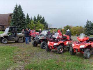
K so this is what we've got:
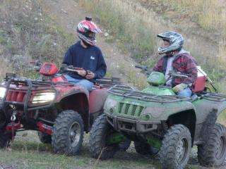
Me & the wifey - AC TRV & 550
My bud Dayton & Dad - AC 700 & 400
Sutter Jr & wife - POPO RAZR 4 seater
Sutter Sn & wife - HONDA Big Red (camo)
"Bear" & wifey & son - POPO 850 & 600
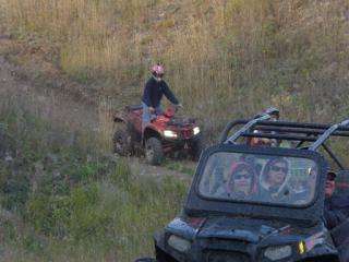
Let's just say the morning started off kinda well.....WET. The roads & ditch's heading out of town to the head of the trail system was a soggy/muddy mess as WALHALLA had just received 2" of rain in the past 24hrs. Our first trail head led by Bear took us 8+ miles out of town and down a challenging trail that unfortunately put us at a nasty wash out that the SBS's (side-by-sides) couldn't navigate.
Turning the group around proved to be a bit of a challenge as the surrounding hills were a VERY greasy/slippery mess and we had a few "nail-biting" moments as some came to rolling their machines - we had a few "newbie" riders....
Not to be deterred he all headed off via the map to explore more trails but found that NEXT few trail heads all ended up being closed.....AFTER we got about 1/2 mile into them...DOUGH!
SO.....turned the group around AGAIN (a very common theme throughout the day) The map provided ended up being the "butt" of more than a few jokes as we were told "ALL TRAILS WOULD BE OPEN". So after about an hour or more of back-tracking and multiple leader changes we eventually ended up at the ski-resort for a much needed break to "ponder" our next move.
SKI-STOP
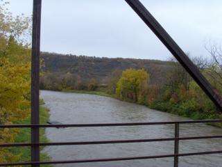
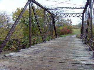
So map in hand...and some good guess-work on myself and Dayton....I took over the lead and basically "winged it" as to how I interpreted the map and hit paydirt! A very nice meandering whinedy trail/road that led us to a very old iron bridge at the bottom of the valley crossing the river.
RIVER STOP:
After a quick lunch, we all took off and I led the group to the top of the valley (again...winging it) and just as we reached the top...the SUN came out!
VALLEY STOP:

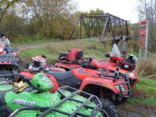
We then decided to get back down to the river and after navigating some steep trails getting there couldn't find ANY trail that actually followed it. But we did find a gravel pit:
Still hunting for more of the actual trail system Dayton took the lead and led us down a VERY nice winding washed-out trail to the bottom of the valley again only to yet again find it dead ended. :icon_head222: The climb back out was very tough. The wifey "lost'r" and put the 550 on it's side after getting caught on a big tree root. She bailed just in time as to not get pinned but it took 3 of us working in "concert" to get the 550 to climb itself out. So her ego bruised a bit the wifey brushed it off and we set out again
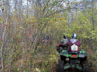
SO now it's 3pm...the hotel is about 1 mile from the look-out point so we all head back to re-fuel and try the opposite direction. - Not 20 min into a VERY nasty tight trail that followed the river bank - we have our 1st clearance casualty - the BIG RED. And is it a bad one - wedged in a tight turn and blocked by a half fallen tree. Can't back-up - can't go forward. And we're ALL jammed up for room to maneuver. :censored: It took pretty much everyone pushing and Dayton on his 700 and myself now using the wifey's 550 (closer to the BIG RED) to winch the dead tree down.
THEN the RAZR got jammed up wedged between trees & bush. THEN the BIG RED got caught AGAIN on low trees.
Needless to say it was a long and tedious crawl back out and as a group it tucker'd us out.
Sorry no pics...I was too busy rescuing the SBS's. Others DID...when I get them I'll post'em.
But I did snap this:
After that it was more hit&miss on finding new trails and lots of going in circles & backtracking...... We decided that with the remaining daylight to re-trace our original route again and then called it a night about 7pm.
DID we have a GREAT time - YES
COULD it have been better - TOUGH CALL
A few general things to note :
1. The map was hand drawn and not very accurate - a GPS map available on-line would have been more helpfull
2. No trail markings - going around in circles and basically guessing where stuff went & finding many of the marked trails closed was disappointing
3. the scenery was absolutely beautiful
4. the trails we did manage to sort out & ride were fun and a little challenging.
I'm sure having a guide or a local willing to "show-us" around would have been extremely helpfull, but over-all we did have a great time and put on about 80 miles in total. I will add as well that the owner's of the FORESTWOOD INN hotel and they're staff were extremely well suited to cater to atv'rs. They are extremely helpfull and are they themselves gearing up to sponsor yearly spring & fall rides that I think will be a definite benefit to the community. VERY friendly.
This WAS a "scouting" trip for pretty much all of us, and we compiled our observations as what we need to do as a group to ensure we get "more bang" for our buck on our next ride.
oh I almost forgot........PROOF I DID GET MUDDY!! thanks to Dayton's dad and Sutter Jr.!!

no photoshop.
Here's some VID links from Dayton's Helmet cam:
Thanks for letting me share!!
The wifey and myself along with 9 other friends from Minot + Grand Forks set-off on a wkend ride to explore the Pembina Gorge in northern ND along the Manitoba border.
I'm not sure if many would consider 50� of cold-damp-wet-foggy conditions "ideal" for a group excursion.....but at 200+ miles just to GET THERE.....we were a motivated bunch.
And with that our group banded together after some much needed coffee in the hotel parking lot and headed out.
Now keep in mind...NONE of us had ever riden here, and we really had no idea where to start. The hotel manager was nice enough to give us a map of the trail system and her parting words of wisdom were : "have fun....but here's my cell no# if you get lost....my husband will come and rescue you"
ummm....OK?
K so this is what we've got:
Me & the wifey - AC TRV & 550
My bud Dayton & Dad - AC 700 & 400
Sutter Jr & wife - POPO RAZR 4 seater
Sutter Sn & wife - HONDA Big Red (camo)
"Bear" & wifey & son - POPO 850 & 600
Let's just say the morning started off kinda well.....WET. The roads & ditch's heading out of town to the head of the trail system was a soggy/muddy mess as WALHALLA had just received 2" of rain in the past 24hrs. Our first trail head led by Bear took us 8+ miles out of town and down a challenging trail that unfortunately put us at a nasty wash out that the SBS's (side-by-sides) couldn't navigate.
Turning the group around proved to be a bit of a challenge as the surrounding hills were a VERY greasy/slippery mess and we had a few "nail-biting" moments as some came to rolling their machines - we had a few "newbie" riders....
Not to be deterred he all headed off via the map to explore more trails but found that NEXT few trail heads all ended up being closed.....AFTER we got about 1/2 mile into them...DOUGH!
SO.....turned the group around AGAIN (a very common theme throughout the day) The map provided ended up being the "butt" of more than a few jokes as we were told "ALL TRAILS WOULD BE OPEN". So after about an hour or more of back-tracking and multiple leader changes we eventually ended up at the ski-resort for a much needed break to "ponder" our next move.
SKI-STOP
So map in hand...and some good guess-work on myself and Dayton....I took over the lead and basically "winged it" as to how I interpreted the map and hit paydirt! A very nice meandering whinedy trail/road that led us to a very old iron bridge at the bottom of the valley crossing the river.
RIVER STOP:
After a quick lunch, we all took off and I led the group to the top of the valley (again...winging it) and just as we reached the top...the SUN came out!
VALLEY STOP:
We then decided to get back down to the river and after navigating some steep trails getting there couldn't find ANY trail that actually followed it. But we did find a gravel pit:
Still hunting for more of the actual trail system Dayton took the lead and led us down a VERY nice winding washed-out trail to the bottom of the valley again only to yet again find it dead ended. :icon_head222: The climb back out was very tough. The wifey "lost'r" and put the 550 on it's side after getting caught on a big tree root. She bailed just in time as to not get pinned but it took 3 of us working in "concert" to get the 550 to climb itself out. So her ego bruised a bit the wifey brushed it off and we set out again
SO now it's 3pm...the hotel is about 1 mile from the look-out point so we all head back to re-fuel and try the opposite direction. - Not 20 min into a VERY nasty tight trail that followed the river bank - we have our 1st clearance casualty - the BIG RED. And is it a bad one - wedged in a tight turn and blocked by a half fallen tree. Can't back-up - can't go forward. And we're ALL jammed up for room to maneuver. :censored: It took pretty much everyone pushing and Dayton on his 700 and myself now using the wifey's 550 (closer to the BIG RED) to winch the dead tree down.
THEN the RAZR got jammed up wedged between trees & bush. THEN the BIG RED got caught AGAIN on low trees.
Needless to say it was a long and tedious crawl back out and as a group it tucker'd us out.
Sorry no pics...I was too busy rescuing the SBS's. Others DID...when I get them I'll post'em.
But I did snap this:
After that it was more hit&miss on finding new trails and lots of going in circles & backtracking...... We decided that with the remaining daylight to re-trace our original route again and then called it a night about 7pm.
DID we have a GREAT time - YES
COULD it have been better - TOUGH CALL
A few general things to note :
1. The map was hand drawn and not very accurate - a GPS map available on-line would have been more helpfull
2. No trail markings - going around in circles and basically guessing where stuff went & finding many of the marked trails closed was disappointing
3. the scenery was absolutely beautiful
4. the trails we did manage to sort out & ride were fun and a little challenging.
I'm sure having a guide or a local willing to "show-us" around would have been extremely helpfull, but over-all we did have a great time and put on about 80 miles in total. I will add as well that the owner's of the FORESTWOOD INN hotel and they're staff were extremely well suited to cater to atv'rs. They are extremely helpfull and are they themselves gearing up to sponsor yearly spring & fall rides that I think will be a definite benefit to the community. VERY friendly.
This WAS a "scouting" trip for pretty much all of us, and we compiled our observations as what we need to do as a group to ensure we get "more bang" for our buck on our next ride.
oh I almost forgot........PROOF I DID GET MUDDY!! thanks to Dayton's dad and Sutter Jr.!!
no photoshop.
Here's some VID links from Dayton's Helmet cam:
Thanks for letting me share!!
#3
09-29-2010, 02:59 PM
Extreme Pro Rider
Mopar Man!
Mopar Man!
Join Date: Jan 2008
Location: Colorado Springs Co
Posts: 6,333
Likes: 0
Received 0 Likes
on
0 Posts
#4
09-29-2010, 06:24 PM


Thread
Thread Starter
Forum
Replies
Last Post
Currently Active Users Viewing This Thread: 1 (0 members and 1 guests)

